Fifty years ago the sea-level rise at the stated locations averaged 2.2mm per year, reduce this proportionately to reflect the wider Ganges then it becomes 1.9mm a year.
Sea-levels rose slowly up until c1980. In 1963 the rise was 1.9mm a year and by 1980 it was around 2.2mm, so 17 years at an ave of 2.05mm per year = 35mm.
From 1981 to 2013 the annual SSL rise went up from 2.2mm to 5.3mm, a fairly steady rise. 33 years at an ave of 3.75mm per year = 124mm. Add to the earlier 35mm = approx 160mm in the last 50 years.
- - - - - - - - -
RE: YOUR ADDED DETAILS.
Thanks. The figures I used came from the South Asian Association for Regional Cooperation Meteorological Research Council and the National Oceanography Centre, they’re in our database so I can’t link to them.
However, the link below also uses data from the SAARC-MRC although these figures are significantly higher than mine (5.9mm per year ave during the 80’s and 90’s, double my figures).
http://wcrp.ipsl.jussieu.fr/Workshops/Se...
Whilst looking for sources I discovered that there’s a tidal gauge on the island next to Bhola at Charchanga (it’s also referenced in the link you provided). This shows a sea-level rise of about 200mm from 1979 to 2000, so again, significantly higher than my figures but in line with the above link.
http://www.psmsl.org/data/obtaining/stat...
The above link is to the PSMSL (Permanent Service for Mean Sea Level), there’s a Data Explorer map that allows you to access the data for tidal gauges around the world, you might find it interesting:
http://www.psmsl.org/data/obtaining/map....
Your second link is to an article by the Swedish geophysicist Nils-Axel Morner. I don’t have much faith in him. He made some odd claims about sea-level rise that he based on satellite readings, these showed sea-levels were rising at about 1.0mm per year. What Morner had done was to fail to calibrate the altimetry data, if he’d have done that he’d have got the same results as everyone else. When asked to reproduce his results he either didn’t or couldn’t.
Some other sources which may be of interest:
http://www.sciencedirect.com/science/art...
http://books.google.co.uk/books?hl=en&lr...
http://www.sciencemag.org/content/316/58...
http://www.asaub.edu.bd/data/asaubreview...
- - - - - - - - -
EDIT: TO MAXX
I think Dr Morner might find it difficult convincing these Tuvaluans that there has been no rise in sea-levels:
http://islandsfirst.files.wordpress.com/2008/06/tuvalutidekids5717braasch.jpg
The figures used for global sea level rise are averaged as there are many other factors that affect local sea levels from winds to geology. Fantasist like "this guy" who is in fact Morner a paid mouth pice for the denial movement, he retired years ago and as can be seen in your own link can't get the nonsense he pushes now in real journals. Frankly I not surprised that those like yourself and max would quote him, and his absurd claims like the one made in the link that "sea level is not actually rising.
Interesting given I'm currently sitting in a science conference at the University of Tasmania with experts on the subject giving talks on current sea level rise and it's history
http://conference.antarctica.gov.au/prog...
Multiple papers have been presented from Australian, New Zealand and International scientists showing sea level rise and the latest evidence on the continuing rates from multiple data sources.
Needless to say nobody here thinks Morner is correct in anyway, but again I'm sure you won't want to hear that.
Morner's claim of no sea level rise shows how far removed from reality he is given the weight of real evidence, why you wish to believe him, rather then the evidence from the real scientific community tells the story of denial, as most denial seems to come down to wanting to believe one retired scientist who has a ridiculous theory with no evidence, while ignoring or trying to dismiss as conspiracy the real science from hundreds of scientists from around the world from multiple groups, this has always been denials problem.
What Morner uses to devine there is no sea level rise is unclear (his belief in dowsing perhaps) while sciences claims are backed by solid data from satellite altimetry that is highly accurate and global and it shows sea level is indeed rising.
http://climate.nasa.gov/key_indicators#s...
There is below the NASA graphs a small global image show variation in sea level rise, Bangladesh is shown in a green range which is moderate sea level rise.
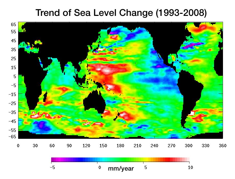
This is not exactly what you want, but nevertheless you may find it interesting. It is a global map of the rate of change of sea level for the period 1993-2008.
http://photojournal.jpl.nasa.gov/jpeg/PI...
7 to 8 cm by the end of the century, Bhola is in danger not because of sea level rise, but because of land erosion.
Something I see presented in Dr. Nils-Axel M?rner paper that I don't see in any of the other 'evidence' presented here is actual photographs of the coastline.
You can tell a lot by looking at a picture. Consider the lower picture found on page 21 of this report: -- http://www.docstoc.com/docs/109185810/Th...
Here you see a photograph of the actual coastline of the island of Tuvalu. In it you can see a concrete structure that slopes down into the water. You can see the high tide and low tide marks on it's surface. Since the water is very shallow in this picture you can see to it's bottom. And you can see that what the water is covering and it is NOT a parking lot, or any kind of man-made surface but simply the ocean bottom of the shoreline. This picture is all the proof I need to know Dr. Nils-Axel M?rner is the one telling the truth.
But there are many other pictures, of many structures. These man-made structures look like they have been in place for decades, yet there is no telltale sign in the photos that the sea is rising on them or that they are about to be covered by ocean. You can see these structures are a normal height out of the water and NOT about to be covered or even threatened.
And in a different report by Dr. Nils-Axel M?rner you can see the famous marker tree of the Maldives on page 35, that was destroyed by man-made Global Warming advocates because it put the lie to their propaganda. http://www.climatechangefacts.info/Clima...
You can believe the 'estimates' from the Warmists organizations if you like but recent history tells us that anything the Warmists have to say should be more than suspect. I'm believing Dr. M?rner, he doesn't seem to be afraid to show his evidence.
-----------------------
In that case, I'll sell you some land there. Although, if you care about your money, or your fellow human beings, I suggest that you stop living in the past and think about the future.
Can anyone tell me the sea level rise for the area of Bhola over say the past 50 years please?
This Bhola Island (also called Dakhin Shahbazpur) is the largest island of Bangladesh with an area of 1441 km2. It is situated at the mouth of the Meghna River.
Thanks.
The figures used for global sea level rise are averaged as there are many other factors that affect local sea levels from winds to geology. Fantasist like "this guy" who is in fact Morner a paid mouth pice for the denial movement, he retired years ago and as can be seen in your own link can't get the nonsense he pushes now in real journals. Frankly I not surprised that those like yourself and max would quote him, and his absurd claims like the one made in the link that "sea level is not actually rising.
Interesting given I'm currently sitting in a science conference at the University of Tasmania with experts on the subject giving talks on current sea level rise and it's history
http://conference.antarctica.gov.au/prog...
Multiple papers have been presented from Australian, New Zealand and International scientists showing sea level rise and the latest evidence on the continuing rates from multiple data sources.
Needless to say nobody here thinks Morner is correct in anyway, but again I'm sure you won't want to hear that.
Morner's claim of no sea level rise shows how far removed from reality he is given the weight of real evidence, why you wish to believe him, rather then the evidence from the real scientific community tells the story of denial, as most denial seems to come down to wanting to believe one retired scientist who has a ridiculous theory with no evidence, while ignoring or trying to dismiss as conspiracy the real science from hundreds of scientists from around the world from multiple groups, this has always been denials problem.
What Morner uses to devine there is no sea level rise is unclear (his belief in dowsing perhaps) while sciences claims are backed by solid data from satellite altimetry that is highly accurate and global and it shows sea level is indeed rising.
http://climate.nasa.gov/key_indicators#s...
There is below the NASA graphs a small global image show variation in sea level rise, Bangladesh is shown in a green range which is moderate sea level rise.
This is not exactly what you want, but nevertheless you may find it interesting. It is a global map of the rate of change of sea level for the period 1993-2008.
http://photojournal.jpl.nasa.gov/jpeg/PI...
7 to 8 cm by the end of the century, Bhola is in danger not because of sea level rise, but because of land erosion.
Something I see presented in Dr. Nils-Axel M?rner paper that I don't see in any of the other 'evidence' presented here is actual photographs of the coastline.
You can tell a lot by looking at a picture. Consider the lower picture found on page 21 of this report: -- http://www.docstoc.com/docs/109185810/Th...
Here you see a photograph of the actual coastline of the island of Tuvalu. In it you can see a concrete structure that slopes down into the water. You can see the high tide and low tide marks on it's surface. Since the water is very shallow in this picture you can see to it's bottom. And you can see that what the water is covering and it is NOT a parking lot, or any kind of man-made surface but simply the ocean bottom of the shoreline. This picture is all the proof I need to know Dr. Nils-Axel M?rner is the one telling the truth.
But there are many other pictures, of many structures. These man-made structures look like they have been in place for decades, yet there is no telltale sign in the photos that the sea is rising on them or that they are about to be covered by ocean. You can see these structures are a normal height out of the water and NOT about to be covered or even threatened.
And in a different report by Dr. Nils-Axel M?rner you can see the famous marker tree of the Maldives on page 35, that was destroyed by man-made Global Warming advocates because it put the lie to their propaganda. http://www.climatechangefacts.info/Clima...
You can believe the 'estimates' from the Warmists organizations if you like but recent history tells us that anything the Warmists have to say should be more than suspect. I'm believing Dr. M?rner, he doesn't seem to be afraid to show his evidence.
-----------------------
In that case, I'll sell you some land there. Although, if you care about your money, or your fellow human beings, I suggest that you stop living in the past and think about the future.
Can anyone tell me the sea level rise for the area of Bhola over say the past 50 years please?
This Bhola Island (also called Dakhin Shahbazpur) is the largest island of Bangladesh with an area of 1441 km2. It is situated at the mouth of the Meghna River.
Thanks.